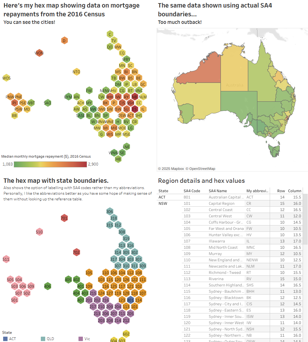
Coverting SA2 into Employment Region or Employment Service Area
Problem in one line:
ABS data is published by SA2, but your stakeholders live in postcodes, employment regions and service areas.
Why This Matters
- Marketing teams segment by postcode, not SA2.
- Policy teams compare Census stats with Employment Regions.
- Providers report outcomes by Employment Service Area.
- The Problem That Keeps Data Analysts Awake at Night Picture this: You're a data analyst or tender team working with Australian Bureau of Statistics (ABS) data, and your stakeholder asks a seemingly simple question: "Can you show me the unemployment rates by employment region (ER) or employment service area (ESA)?" Your heart sinks. The data you have is coded to Statistical Area Level 2 (SA2), but your stakeholder needs other information. What should be a 5-minute task suddenly becomes a multi-day research project into the labyrinthine world of Australian statistical geography. If this scenario sounds familiar, you're not alone. The conversion of SA2 codes to practical, business-relevant geographies like postcodes, employment regions, and employment service areas is one of the most persistent pain points in Australian data analytics.
What Are SA2s and Why Do They Exist?
Statistical Area Level 2 (SA2) regions are medium-sized areas designed by the ABS to represent communities that interact together socially and economically. With populations typically ranging from 3,000 to 25,000 people, SA2s serve as the backbone of Australian statistical reporting. The Good:
- Consistent boundaries designed for statistical integrity
- Stable over time (updated only every 5 years)
- Represent genuine socioeconomic communities
- Available for all ABS datasets
The Pain Points:
- Don't align with business-familiar boundaries (postcodes, suburbs)
- Incompatible with most CRM and marketing systems
- Complex many-to-many relationships with postcodes
- Limited support in commercial GIS and mapping tools
The Real-World Impact:
In my experience working with government agencies, retailers, and service providers, I've seen this SA2 conversion challenge manifest in several ways:
- Marketing Teams can't segment campaigns by postcode when using ABS socioeconomic data
- Policy Analysts struggle to align census data with service delivery areas
- Researchers spend weeks manually matching geographies instead of analyzing data
- Business Intelligence Teams abandon rich ABS datasets in favor of inferior but "postcode-compatible" alternatives
The Employment Geography Challenge
While SA2-to-postcode conversion is challenging enough, converting to employment-related geographies adds another layer of complexity.
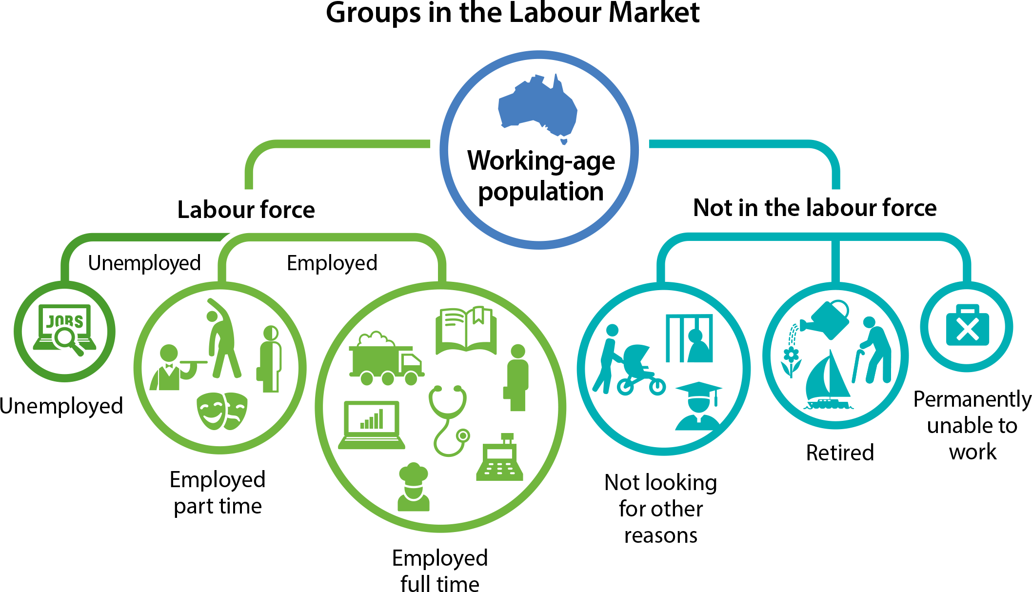
Employment Regions vs Employment Service Areas Australia's employment support system operates across two key geographical frameworks:
- Employment Regions (51 regions nationally)
Large areas designed for labour market analysis Used for workforce planning and economic development Built from aggregated SA2s but boundaries don't always align perfectly
- Employment Service Areas (110+ regions)
Smaller operational areas for employment service delivery Used by Job Active providers and government employment services Often cut across SA2 boundaries based on service delivery logistics
The Data Integration Nightmare Consider this real scenario: You're analyzing the relationship between local unemployment rates (available by SA2) and employment service outcomes (reported by Employment Service Area). The geographical misalignment means:
23% of SA2s span multiple Employment Service Areas 15% of Employment Service Areas contain partial SA2s Standard GIS joins produce inaccurate results Population-weighted allocation becomes necessary
A Python-Powered Solution: From Pain to Gain After years of wrestling with these conversions manually, I developed a systematic approach using Python and modern geospatial tools.
The Employment Geography Challenge
- Emerging Solutions The Australian data landscape is evolving, with several promising developments:
ABS API Improvements: More programmatic access to correspondence files Open Data Initiatives: Better availability of historical boundary data Community Contributions: Projects like Matthew Proctor's database gaining traction Commercial Solutions: GIS vendors adding Australian-specific conversion tools
Conclusion: From Frustration to Systematic Success
Converting SA2 codes to practical geographies doesn't have to be a nightmare. With the right combination of data sources, tools, and methodologies, what once took days can be reduced to hours—or even automated entirely. The key insights from my journey:
Embrace Multiple Data Sources: No single source provides complete coverage Invest in Quality Assessment: Understanding your data's limitations prevents downstream errors Build Reusable Workflows: Create modular, well-documented processes Validate Relentlessly: Trust but verify, especially for business-critical applications Stay Connected: The Australian geospatial community is small but helpful
Next Steps
If you're facing similar SA2 conversion challenges, I recommend:
- Start Small: Begin with a pilot project in one state or region
- Build Incrementally: Add complexity and data sources gradually
- Document Everything: Your future self (and colleagues) will thank you
- Share Your Results: Contribute back to the community knowledge base
The pain of SA2 conversion is real, but with systematic approaches and modern tools, it's a solvable problem. The investment in building robust conversion workflows pays dividends in improved data quality, faster analysis, and better business outcomes.
Have you wrestled with SA2 conversions in your own work? I'd love to hear about your approaches and challenges. Connect with me on hello@ozsparkhub.com.au . Let's make Australian geospatial data more accessible together.
Coverting SA2 into Employment Region or Employment Service Area
https://www.ozsparkhub.com.au/2. Data Grove/Converting-SA2-into-Employment-Region/